
Incendiary Traces is a collective exploration of the powerful role of landscape imagery in international conflict. It takes Southern California’s subtropical landscape as a starting point for drawing connections to seemingly remote wars in similar latitudes and beyond. The project is based on the premise that insights about contemporary US national identity can be discovered by exploring art and non-art forms of landscape observation, demarcation and drawing. This essay is an opportunity to reflect on the project to date –its origins, its varied forms, and its developing focus through these investigations.
Since Incendiary Traces began in early 2011, the exploration has developed through a series of thematically linked activities. These include a panel discussion, draw-ins, research, and publication of contemporary and historic materials. The draw-ins are public events organized around militarized areas in and near Southern California. The sites are each in some way involved in picturing international conflicts such as developing satellite technologies, delineating national boundaries and simulating distant battlefields. Artists, writers, geographers, scholars, and others gather on-site for observation, imaging and discussion with experts on the location’s history and current use. Through this engagement, participants consider who is ‘looking,’ and at what, for what, how, and why. Related materials published on Artbound provide additional insights. An archive of digital and physical materials is developing from these activities.
Here I present the themes around which the project was organized over the past year-and-a-half, and examine some of the insights revealed through this process.
1. Introduction

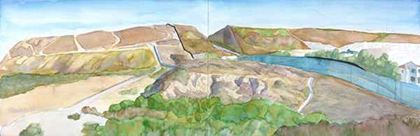
"Los Angeles, 2010," Hillary Mushkin, watercolor and pencil on paper, 9 x 11 inches, detail, 2011

"Baghdad, 1991," Hillary Mushkin, watercolor and pencil on paper, 9 x 11 inches, detail, 2011

Draw-in at the Los Angeles Air Force Base, 2011. | Photo by Hillary Mushkin
These image essays provide background on the origination of the project including its first iterations as an image essay for the Los Angeles Forum for Architecture and Urban Design and a pilot draw-in at the Los Angeles Air Force Base in El Segundo.
Welcome to Incendiary Traces by Hillary Mushkin
Drawing, the Rules of Perspective and National Security by Hillary Mushkin
2. Landscape as Occupied Territory
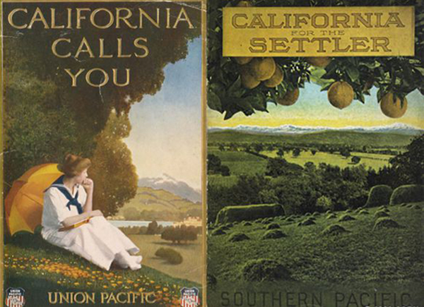
Figure 1 (Left): "California Calls You," ca. 1900. Union Pacific Railroad pamphlet, University of California-San Diego Special Collections; Figure 2 (Right): "California for the Settler: The Natural Advantages of the Golden State for the Present Day Farmer," ca. 1910. Pamphlet cover, Southern Pacific Company. Courtesy of the California State Railroad Museum Library
19th and early 20th C Southern California landscape imagery offered an historical point of entry to our inquiry. Subtropical Edenic portrayals played an instrumental role in the US military and imperial westward expansion. The idyllic nature of these representations served manifest destiny policies by luring investors and Anglo settlers to the contested Southern California region.
How a 19th Century Painting Transformed California's Desert World by Susanna Newbury
Even Our Palm Trees Are Cooler by Janet Owen Driggs
3. The Subtropical Fantasy and Military - Imperial Landscapes of the Pacific
![View of the Islands of Otaha [Taaha] and Bola Bola [Bora Bora] with Part of the Island of Ulietea [Raiatea], William Hodges, oil on canvas, 345 x 516 mm, 1773. National Maritime Museum, Greenwich, London, Ministry of Defense Art Collection](https://images.squarespace-cdn.com/content/v1/528d39d1e4b0d60933da00ae/1399315885157-CXXALGRO8LGCHPRCFQ0X/image-asset.jpeg)
View of the Islands of Otaha [Taaha] and Bola Bola [Bora Bora] with Part of the Island of Ulietea [Raiatea], William Hodges, oil on canvas, 345 x 516 mm, 1773. National Maritime Museum, Greenwich, London, Ministry of Defense Art Collection

After Hodges: coastal profiles of So. CA's own San Clemente Island, Hillary Mushkin, watercolor and pencil on paper, 9 x 11 inches, 2012

"Undersea sonar recordings," Tom McMillin, sonar recordings, 8.5 x 5.5 inches, circa 1980. | Photo: Hillary Mushkin
Where did idyllic Anglo fantasies of the Southern California region originate? We may find precedence in British naval artist William Hodges’s images of Tahiti and Bora Bora, sketched during Capt. Cook’s voyages. Broadly disseminated, the authoritative, realistic eyewitness images were a groundbreaking Naval tactic for imperial cultural expansion. For contemporary comparison, Incendiary Traces looked at one of Southern California’s own Naval Pacific islands.
San Clemente Island is the only active ship-to-shore US Naval weapons testing range in the world. SEALs, Special Ops, US allies and others come here to imagine being in the midst of port seizures and coastal conflicts. However, such scenarios seem abstract and remote to most US civilians.
Incendiary Traces gained some insights through a draw-in on a fishing boat in the waters around San Clemente Island, interviews with experts, and an investigation of archival materials and artworks. Our activities revealed the complexities of civilian co-existence with the military in an active battle space and the role of natural landscape imagery in military land use policy. We considered a broad range of approaches to picturing military-imperial Pacific landscapes including sonar recordings, satellite imagery, WWII era video documentation, and artists’ depictions. Together, these observations and materials help the uninitiated visualize the military and imperial associations of Pacific island landscapes in our own backyard.
Tracing the San Clemente Island Weapons Testing Range by Hillary Mushkin
Johnston Island Saturday Night by Steve Rowell
The Naval Gaze: (Sub)tropical Fantasies and Imperial Pacific Landscapes by Hillary Mushkin
Report on San Clemente Island Draw-in by Hillary Mushkin with video by Suzanne Mejean
4: Visualizing Landscape in Conflict: Technological Views and Military “Sight”

"Radome, Northrop Grumman Space Park Drive Aerospace HQ," Hillary Mushkin, watercolor and pencil on paper, 9 x 11 inches, 2012

Courtesy of Northrop Grumman Corporation

Today, military views of landscapes are largely technological – battlefields are observed and analyzed with GIS tools, satellites, and complex systems integrating surveillance, communications, remote control, and other features. Many of these technologies are researched and tested inside buildings topped with a radome and satellite dishes at Northrop Grumman Aerospace HQ.
Incendiary Traces held a draw-in, researched and published materials to better understand the roles of technological and on-the-ground human observation in conflict zones and the range of military, NGO and public engagement with these technologies. A comparison of human and technological methods along with ground and aerial views highlighted the disjuncture between our vision of traditional battlefields (open land, on the ground) and the hybrid, dispersed shape of contemporary battle space. Furthermore, our image of contemporary battle space included the instruments we were looking at (radomes, antennae, etc.) and the physical site we shared with them, undisturbed and unharmed.
Los Angeles: Camouflage and Contestation by Jason Weems
Drawing with Satellites, Tracing Landscapes With a Mission Interview with Joel Myhre by Hillary Mushkin
Report on an Incendiary Traces Draw-in at Northrop Grumman Aerospace Headquarters by Hillary Mushkin
5: Drawing Lines of Site, Sight: National Identity and Land Surveying

John Weyss, "View from Emory's Monument South of the San Luis Springs Looking West across the Parallel of 31°20'," engraved by W.H. Dougal, ca. 1856. Plate from William Emory, "Report on the United States and Mexico Boundary Survey, 1857, vol. 1."

Border Monument No. 2 - N31º47.032' W106º32.239' | Photo ©2012 David Taylor

"USA-USA-USA #5," Scott Polach, site specific installation with PVC landscaping flags, 2012. | Photo by Scott Polach

Draw-in at Border Field State Park, 2012. | Photo by Maria Teresa Fernandez
International boundaries are political concepts that are (to varying degrees) embodied on the ground, drawn through a variety of methods that intertwine imaging, observation and national security. Incendiary Traces considered the San Diego/Tijuana border to understand the role of landscape imaging in defining US national identity. A draw-in brought participants to a place where delineation of national boundaries is a 24/7 activity. The border wall functions as a physical and political line, and the border patrol agents methodically observe the line, in tandem with surveillance systems.
Concurrently, we explored the history of drawing this political and physical line, starting with an international commission of 19Th Century mapmakers and surveyors. We also looked at the contemporary legacy of this historic delineation including its physical manifestation and how people who live on the land coexist with survey markers, monuments, walls and security systems.
This segment underscores some of the most exciting discoveries Incendiary Traces made: that methodical forms of observing and recording the landscape are both military tools and artists tools; that on-the-ground observation is a partner to technological viewing; that they, together, make up a dispersed battle space; that physical and political landscape are inseparable; and that contemporary battle space is, in this case, habitable and inhabited by civilians at home in the US.
Drawing a Line: Encounters with the U.S.-Mexico Border by Susanna Newbury
A Brief History of Border Walls by Jena Lee
The Journey to Border Monument Number 140 by David Taylor
Battlefields of Santa Barbara by Jason Hill
Tracing the U.S. / Mexico Border Wall by Hillary Mushkin
6: Simulations and Replicas: Foreign Territory at Home

Twentynine Palms MCAGCC mock village, pencil on paper by Andy Wilcox, 2013

Twentynine Palms MCAGCC mock village. | Polaroid by Claudia Martinez Mansell, 2013
In this segment, Incendiary Traces turned to Middle Eastern fantasies that have been grafted upon the SoCal desert by civilian and military stakeholders with varied interests. A draw-in at the 29 Palms Marine Base mock villages and simulation center allowed us to consider the role the California desert landscape plays in training marines to visualize distant, but geographically similar war zones, such as Iraq and Afghanistan. In tandem, we considered the more than 100-year history of Indio/Palm Springs as a stand in for the Middle East in the intertwined development of a US date industry and real estate in the area. Comparing military and civilian images of the same region alongside our own image-making there, we compared the political complexities of simulating the Middle East in Southern California.
Harem Girls and Camel Races: Middle Eastern Fantasies in the Deserts of Southern California by Sarah McCormick Seekatz
The Simulators by David Buuck
Drawing the Twentynine Palms Marine Corps Air Ground Combat Center by Jena Lee and Hillary Mushkin

Guests at California's Biskra who arrived on Camelback
Incendiary Traces initially set out with a question: Can landscape imagery help us understand seemingly remote war? Through this process we developed the following perspectives:
1. We redefined the seemingly remote battlefield and its image as local, dispersed, and inhabited by US civilians. Military mock villages and port cities, satellite, remote control and communications technologies facilities, and simulated road blocks are nested within Southern California’s populated public streets, waterways, and airwaves.
2. We identified and compared a broad range of forms for imaging battlefields. Included are depictions of contested international territories by artists, the military and others, from watercolors to navigation charts, direct on-the-ground observation to satellite imagery, surveillance to sonar recordings, citizen disaster mapping to C4SIR systems and more.
3. We discovered a range of political facets to landscape imaging and imagery. Whether a border patrol agent’s ocean gaze, a sheriff’s forensic photograph, an aerial photograph or an artist’s eyewitness representation, we found that lines and sight define lines of site. That is, authoritative views, supported by systematic observation and recording methods, are instrumental in defining, delineating and defending national identity and shaping policy.

Untitled (Ellwood Shelling), Ralph Bradford, 1942 | Courtesy Paul Petrich, Jr.
These insights provide a new foundation for understanding the role of landscape imagery in international relations. Moreover, they prompt new questions. What on-the-ground methods do the military and other conflict professionals have for observing, recording, representing and physically navigating active battle spaces? How do civilians observe, represent, navigate and move within active conflict zones? How is battle space pictured in the design of national security architecture and engineering documents? What role does landscape imagery play in the interface design of instruments used for viewing and controlling battle spaces? How can we widen our comparative perspective further?
These questions probe deeper into the integrated nature of abstract, political concepts with on-the-ground experience of national security, identity, and territorial delineation. We will begin to address some of these questions in future investigations while continuing to explore actual and metaphorical forms of drawing and tracing.