• Projects
  • Exhibitions
  • Publications
  • About
  • Contact
Menu

Incendiary Traces

Street Address
Los Angeles
Phone Number
An art, research and media project investigating the role of landscape imagery in international conflict through drawing events at militarized sites and publications.

Your Custom Text Here

Incendiary Traces

  • Projects
  • Exhibitions
  • Publications
  • About
  • Contact
2 03 _ Thumbnail.jpg

Blog

The Journey to Border Monument Number 140

December 18, 2012 David Taylor
Border Monument No. 2 - N31º47.032' W106º32.239', 2012 | Photo courtesy of David Taylor

Border Monument No. 2 - N31º47.032' W106º32.239', 2012 | Photo courtesy of David Taylor

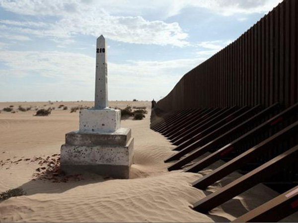
David Taylor set out to photograph each of the 276 obelisks installed by the International Boundary Commission following the Mexican/American War.

Read More
In Guest Contribution, Historical Tags US/Mexico Border, Border Patrol

A Brief History of Border Walls

December 4, 2012 Jena Lee
Graffiti and trash along the barrier that divides Israel from the Palestinians in West Bank | Courtesy of Goatmilk, via NYTimes.com

Graffiti and trash along the barrier that divides Israel from the Palestinians in West Bank | Courtesy of Goatmilk, via NYTimes.com

Incendiary Traces lists historical and contemporary border walls to provide some global and historical context for understanding Southern California's contested US/Mexico border.

Read More
In Historical, Guest Contribution, Origins Tags US/Mexico Border, Border Patrol

Drawing a Line: Encounters with the U.S.-Mexico Border

November 13, 2012 Susanna Newbury
David Taylor, Boundary Monument No. 210, 2009. From the series Working the Line. Archival inkjet print, 31 x 24 in. | Photo courtesy of David Taylor

David Taylor, Boundary Monument No. 210, 2009. From the series Working the Line. Archival inkjet print, 31 x 24 in. | Photo courtesy of David Taylor

Susanna Newbury examines the history of the U.S./Mexico border and its geopolitical importance to the United States.

Read More
In Guest Contribution, Historical Tags US/Mexico Border, Border Patrol, San Diego, Cartography

Draw-in at Northrop Grumman Aerospace Headquarters

October 30, 2012 Hillary Mushkin
Radome, Housing protecting radar antennae | Drawing : Hillary Mushkin

Radome, Housing protecting radar antennae | Drawing : Hillary Mushkin

Incendiary Traces gathered at Northrop Grumman's Aerospace Headquarters to contemplate looking, drawing, recording, and representing landscape at the home of military "sight."

Read More
In Report Tags Northrop Grumman, Redondo Beach, C4ISR

Drawing with Satellites: Tracing Landscapes With a Mission

October 9, 2012 Hillary Mushkin
Project Haiti, screen shot | Courtesy of OpenStreetMap

Project Haiti, screen shot | Courtesy of OpenStreetMap

Incendiary Traces considers crisis mapping as another form of visualization that can help us, as ordinary citizens, understand seemingly remote wars.

Read More
Tags Northrop Grumman, Redondo Beach, C4ISR, Cartography

Los Angeles: Camouflage and Contestation

September 20, 2012 Jason Weems
Bird's eye view of Disneyland in Anaheim, California, 1958 | Courtesy of Stuff from the Park Blog

Bird's eye view of Disneyland in Anaheim, California, 1958 | Courtesy of Stuff from the Park Blog

Art historian Jason Weems examines three mid-century constructions understood as staples of the California landscape: Disneyland, Lakewood, and the aerospace industry.

Read More
In Guest Contribution, Historical, Origins Tags Disneyland, World War II, Los Angeles, Northrop Grumman

San Clemente Island Draw-in

September 6, 2012 Hillary Mushkin

Incendiary Traces ventures out on the sport fishing boat Fury for an unannounced draw-in focused on San Clemente Island Naval Weapons Testing Range.

Read More
In Report Tags San Clemente Island, US Navy, Pacific

The Naval Gaze: (Sub)tropical Fantasies and Imperial Pacific Landscapes

August 14, 2012 Hillary Mushkin
Detail of Map of California shown as an island, Joan Vinckeboons, 1650 | Courtesy of Geography and Map Division, Library of Congress

Detail of Map of California shown as an island, Joan Vinckeboons, 1650 | Courtesy of Geography and Map Division, Library of Congress

Hillary Mushkin examines early European representations of the Southern California coast.

Read More
In Historical Tags Pacific, San Clemente Island, US Navy, Cartography

Tracing the San Clemente Island Weapons Testing Range

July 17, 2012 Hillary Mushkin
Installation view of Documentation as Art/Art as Documentation, exhibit at ARCO Center for Visual Art, 1979 | Photo : Tom McMillin

Installation view of Documentation as Art/Art as Documentation, exhibit at ARCO Center for Visual Art, 1979 | Photo : Tom McMillin

San Clemente Island is the subject of a draw-in on the deck of a sport fishing boat named "The Fury".

Read More
Tags San Clemente Island, US Navy, Pacific, World War II

'Even Our Palm Trees Are Cooler'

July 3, 2012 Janet Owen Driggs
San Pedro palm being brought to Fifth Street and Central Avenue for depot, 1889 | Courtesy of USC Libraries Special Collections

San Pedro palm being brought to Fifth Street and Central Avenue for depot, 1889 | Courtesy of USC Libraries Special Collections

Incendiary Traces examines the role that real estate and the railroad played in the advertisement of Southern California as a fertile tropical utopia in the late 1800s.

Read More
In Historical, Guest Contribution, Origins Tags Los Angeles

How a 19th Century Painting Transformed California's Desert World

June 19, 2012 Susanna Newbury
(Left) "California Calls You", Union Pacific Railroad pamphlet, University of California-San Diego Special Collections, circa 1900 | (Right) "California for the Settler: The Natural Advantages of the Golden State for the Present Day Farmer", Pamphle…

(Left) "California Calls You", Union Pacific Railroad pamphlet, University of California-San Diego Special Collections, circa 1900 | (Right) "California for the Settler: The Natural Advantages of the Golden State for the Present Day Farmer", Pamphlet cover, Southern Pacific Company, circa 1910 | Courtesy of the California State Railroad Museum Library

In the late 19th century, Southern California's human and natural geography transformed as millions of new residents settled its semi-arid desert world, but artistic renditions of this region seldom get the attention of its northerly neighbors. But why is this the case?

Read More
In Guest Contribution, Historical, Origins

Drawing, the Rules of Perspective, and National Security

May 21, 2012 Hillary Mushkin
Artists Robby Herbst and Susan Siltonn | Photo : Hillary Mushkin

Artists Robby Herbst and Susan Siltonn | Photo : Hillary Mushkin

Hillary Mushkin and a small group of artists and writers sat outside of the Los Angeles Air Force Base sketching and reading poetry. When their quiet session caused alarm, their conversation turned to the legality of looking.

Read More
In Report, Reconnaisance Tags El Segundo, LA Air Force Base

What is Incendiary Traces?

May 1, 2012 Hillary Mushkin
Drawing by Hillary Mushkin

Drawing by Hillary Mushkin

Conceived by artist Hillary Mushkin, Incendiary Traces is a conceptually driven, community-generated art project that explores the political act of representing the Southern California landscape by creating a series of drawing events in different militarized locations across the region.

Read More
← Newer Posts

© HILLARY MUSHKIN 2025