• Projects
  • Exhibitions
  • Publications
  • About
  • Contact
Menu

Incendiary Traces

Street Address
Los Angeles
Phone Number
An art, research and media project investigating the role of landscape imagery in international conflict through drawing events at militarized sites and publications.

Your Custom Text Here

Incendiary Traces

  • Projects
  • Exhibitions
  • Publications
  • About
  • Contact
2 03 _ Thumbnail.jpg

Blog

Imagining Global War: Popular Cartography during World War II

September 2, 2014 Tatsiana Zhurauliova

A look at American cartographic representations of WWII Europe, providing historical context for understanding our conception of global space.

Read More
In Historical, Guest Contribution, Origins, EU Border Tags World War II, Cartography, EU Border

Drawing a Line: Encounters with the U.S.-Mexico Border

November 13, 2012 Susanna Newbury
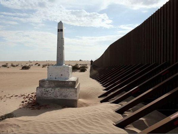
David Taylor, Boundary Monument No. 210, 2009. From the series Working the Line. Archival inkjet print, 31 x 24 in. | Photo courtesy of David Taylor

David Taylor, Boundary Monument No. 210, 2009. From the series Working the Line. Archival inkjet print, 31 x 24 in. | Photo courtesy of David Taylor

Susanna Newbury examines the history of the U.S./Mexico border and its geopolitical importance to the United States.

Read More
In Guest Contribution, Historical Tags US/Mexico Border, Border Patrol, San Diego, Cartography

Drawing with Satellites: Tracing Landscapes With a Mission

October 9, 2012 Hillary Mushkin
Project Haiti, screen shot | Courtesy of OpenStreetMap

Project Haiti, screen shot | Courtesy of OpenStreetMap

Incendiary Traces considers crisis mapping as another form of visualization that can help us, as ordinary citizens, understand seemingly remote wars.

Read More
Tags Northrop Grumman, Redondo Beach, C4ISR, Cartography

The Naval Gaze: (Sub)tropical Fantasies and Imperial Pacific Landscapes

August 14, 2012 Hillary Mushkin
Detail of Map of California shown as an island, Joan Vinckeboons, 1650 | Courtesy of Geography and Map Division, Library of Congress

Detail of Map of California shown as an island, Joan Vinckeboons, 1650 | Courtesy of Geography and Map Division, Library of Congress

Hillary Mushkin examines early European representations of the Southern California coast.

Read More
In Historical Tags Pacific, San Clemente Island, US Navy, Cartography

© HILLARY MUSHKIN 2025